Mapping India’s Climate Vulnerability
A District-Level Assessment
By Abinash Mohanty and Shreya Wadhawan
OVERVIEW
This study undertakes India’s first-of-its-kind district-level climate vulnerability assessment. It presents a climate vulnerability index (CVI) of states and union territories by mapping exposure, sensitivity, and adaptive capacity. A CVI would help to map critical vulnerabilities, and plan strategies to enhance resilience and adapt by climate-proofing communities, economies, and infrastructure. Instead of looking at climate extremes in isolation, the study looks at the combined risk of hydro-met disasters and their compounded impacts on vulnerability.
KEY FINDINGS
- More than 80 percent of India’s population lives in districts highly vulnerable to extreme hydro-met disasters
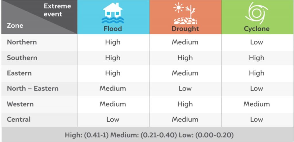
- The southern zone of India is the most vulnerable to extreme climate events and their compounding impacts, followed by the eastern, western, northern, north-eastern and central zones.
- 59 and 41 per cent of the total districts in the eastern and western zones of India are highly vulnerable to extreme cyclone events.
- The states located in India’s northeast are more vulnerable to floods, whil the states in the southern and central parts are more vulnerable to extreme droughts.
- Five out of six zones in India, i.e., South, North, North-East, West and Central have a low adaptive capacity to extreme hydro-met disasters. However, the Eastern Zone has a medium-range adaptive capacity to extreme hydro met disasters.
- Assam, Andhra Pradesh, Maharashtra, Karnataka and Bihar are highly vulnerable to extreme climate events such as floods, droughts and cyclones, according to the Climate Vulnerability Index (CVI).
- Unsustainable landscape, lack of infrastructure planning and human-induced microclimate change are the key drivers of this high vulnerability.
Southern-zone is the most vulnerable to all three hydro-met disasters

India urgently needs national and sub-national strategies to climate-proof its population and economic growth.


